


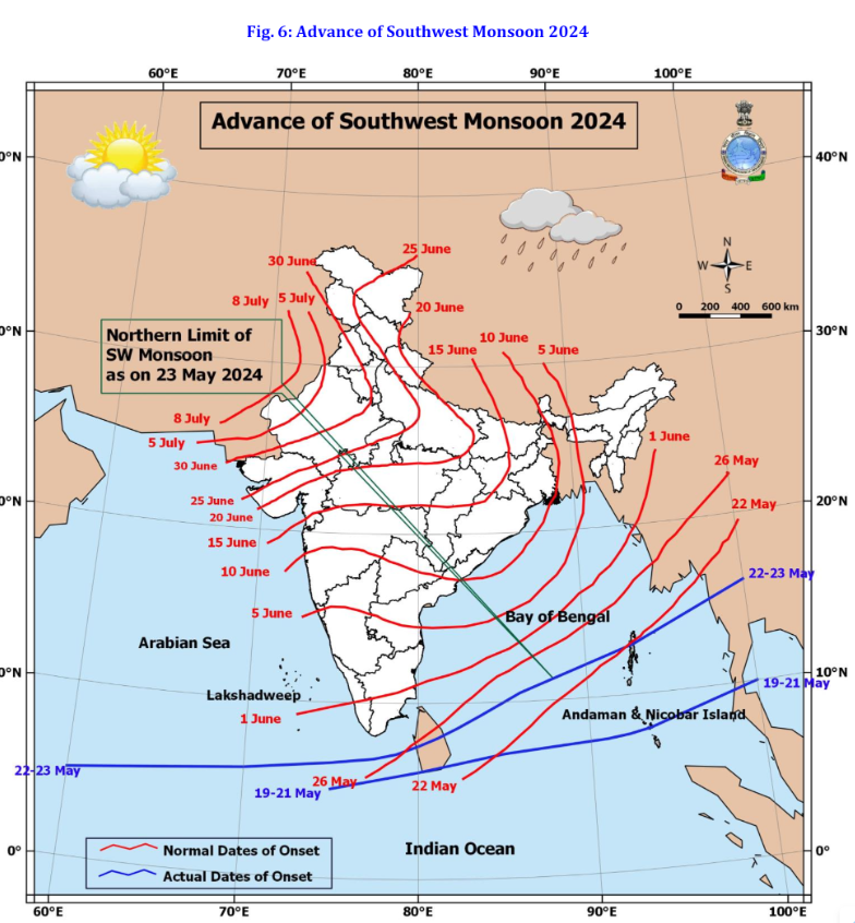
Monsoon
In the last 24 hours, the monsoon didn't progress but in the next 24 hrs, the conditions are more favorable for further advancement of Southwest monsoon in the remaining parts of Andaman and Nicobar Island, Andaman Sea, and some more parts of South And east-central Bay of Bengal. Look at the below advancement of the southwest monsoon 2024 figure, it is taken from the IMD website.
Kerala & Tamilnadu Rains
For the past 4 days Kerala and some parts of southern Tamilnadu were lashed by moderate to heavy rains, few places witnessed very heavy rains which caused flooding. It’s because the twin weather systems have an impact on both the states. First is a low-pressure area off Kerala coast and second is the well-marked low-pressure area over west-central & south bay of Bengal.
For 24th May, the rains are likely to continue in both the states. Kerala is likely to get widespread rains whereas rains will pause in northern Tamilnadu. The southern tip of Tamilnadu will receive moderate to heavy rains. Southern & central parts of Kerala will get heavy rains, isolated places might get very heavy rains. North Kerala will mostly get light to moderate rains accompanied by thunderstorms. Post-24th May rains will also reduce in Kerala and the remaining parts of Tamil Nadu.

The Heat Wave in Northwest & parts of West India
Heatwave to severe heatwave conditions will continue in Rajasthan and parts of Chhattisgarh, West Uttar Pradesh, and Delhi till 27th May. The dry northerly winds will continue to keep this region super hot. People in this region should remain hydrated, and stay indoors during afternoon hours.
In the below images, we can see that most parts of Rajasthan, Gujarat, west m.p, and parts of north Madhya Maharashtra observed 1.6 to 4.5 C above average temperatures. Comparatively southern india measured largely below-average temperatures.

Well Marked Low-Pressure Area in the Bay of Bengal
According to IMD, the well-mark Low-pressure area over the Bay of Bengal will concentrate into a depression early tomorrow morning. Further, it will intensify into a deep depression and cyclonic storm by the early morning of 25th May, further, it is expected to intensify into a severe cyclonic storm by 26th May evening and cross between West Bengal and Bangladesh coast. What we think is the door is open for the storm to make landfall between Odisha and Bangladesh coast. As soon as the well-marked low pressure area forms into a cyclonic storm then we will have an idea of the exact track of the cyclonic storm.
The impact of the cyclonic storm on the Southwest monsoon is not going to be huge as it is going to be beneficial for the Southwest monsoon to progress into the Andaman and Nicobar Islands and further cover some more parts of the Bay of Bengal.
We are waiting for IMD to officially announce the southeast monsoon onset in Kerala. They have predicted that the Southwest monsoon will make an onset in Kerala around 31st May +/- 4 days.


0 Comments
Please do not enter any spam link in the comment box.