All India Weather Forecast 8th Mar 2020:
 |
| All India Weather Forecast 8th Mar 2020: Light to Moderate Rains in Northeast India |
India:
Snowfall: Due to the Western Disturbance the union territories Jammu & Kashmir, as well as higher reaches of Himachal Pradesh and Uttarakhand are very likely to observe light snowfall at a few places. Arunachal Pradesh is likely to observe light to moderate snowfall at few places, eastern parts of Arunachal Pradesh will be the most affected region.
Rain: Due to the Western Disturbance the union territories Jammu & Kashmir, as well as higher reaches of Himachal Pradesh and Uttarakhand, are very likely to observe light rain at isolated places, Due to the cyclonic circulation over the central parts of the Assam entire northeast India is very likely to witness light to moderate rains. Due to the trough, Vidarbha, Chattisgarh and one or two places of Telangana might observe light rains. The remaining regions of the country are very likely to remain dry.
Temperature: No significant change in maximum and minimum temperature of the country in the next 24 hours.
Wind: Nil.
Fog: Shallow to moderate fog likely at few places in northwest India, East, and Northeast India.
Cold-Wave Conditions: Nil.
Thunderstorm: due to the Western Disturbance isolated places of Jammu & Kashmir might observe light thunderstorms. There is a slim chance of a light thunderstorm occurring over the regions of Arunachal Pradesh and Assam.
- The lowest minimum temperature of 11.5 C was recorded at Narnual in Haryana over the plains of the country.
- The highest maximum temperature of 38.0 C was recorded at Madurai in Tamilnadu.
Meteorological Analysis by IMD (Based on 1730 hours IST):
- The Western Disturbance as a cyclonic circulation over central Pakistan & neighborhood between 3.1 & 5.8 km above mean sea level with the trough aloft with its axis at 7.6 km above mean sea level roughly along Long 70, °E to the north of Lat 26°N persists.
- The induced low-pressure area over central parts of West Rajasthan & adjoining Pakistan with the associated cyclonic circulation extending up to 2.1 km above mean sea level persists.
- The cyclonic circulation over central Assam & neighborhood extending up to 2.1 km above mean sea level persists.
- The trough from Vidarbha to Rayalaseema at 0.9 km above mean sea level persists.
- The cyclonic circulation over Sub-Himalayan West Bengal & neighborhood between 1.5 & 2.1 km above mean sea level persists.
- The cyclonic circulation over the southeast Arabian Sea off Kerala coast at 0.9 km above mean sea level persists.
- A fresh Western Disturbance likely to affect Western Himalayan region from the night of 10th March, 2020.
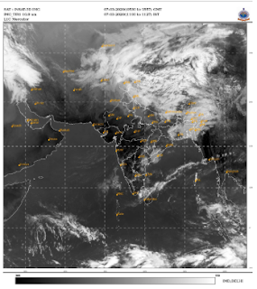
Satellite Image (Based on 5:30 hours IST):
 |
| IMD Satellite Image |
Region-wise Rainfall Statistics:
 |
| IMD Rain Stats |
Upcoming Weather Systems:
A fresh Western Disturbance is likely to affect Western Himalayan Region & adjoining plains from 10th March.


0 Comments
Please do not enter any spam link in the comment box.