All India Weather Forecast 19 Feb 2020:
India:
 |
| All India Weather Forecast 19 Feb 2020: Snowfall in J&K, Sikkim & Arunachal Pradesh |
India:
Snowfall: Due to the Western Disturbance over Jammu & Kashmir, the union territories Jammu & Kashmir, as well as higher reaches of Himachal Pradesh, are very likely to observe light snowfall at few places. The Uttrakhand state will remain almost dry with one or two places observing snowfall. Sikkim & Arunachal Pradesh is likely to witness light snowfall at isolated places.
Rain: Due to the Western Disturbance over Jammu & Kashmir, the union territories Jammu & Kashmir and Himachal Pradesh will receive light rains at few places. Kerela, Sikkim & Arunachal Pradesh will receive light rains at one or two places. The remaining regions of the country are very likely to remain dry.
Temperature: The minimum temperature of northwest India and west India is very likely to rise by a couple of degrees, the reason for such rise is due to the W.D, Due to which south-easterly winds will replace the northwesterly winds causing a rise in minimum temperature. The minimum temperature of central India will rise tomorrow. No significant change in the temperature of the rest of the country.
Wind: Nil.
Fog: Shallow to moderate fog likely at isolated places in Northeast India, Dense fog likely at isolated places of Odisha.
Cold-Wave Conditions: Nil
Thunderstorm: Sikkim & Arunachal Pradesh might receive thunderstorms at one or two places.
- The lowest minimum temperature of 5.0 C was recorded at Alwar in East Rajashtan over the plains of the country.
- The highest maximum temperature of 37.5 C was recorded at Vengurla in Konkan.
Meteorological Analysis by IMD (Based on 1730 hours IST):
- The Western Disturbance as a cyclonic circulation over Kashmir & neighborhood at 3.6 km above mean sea level persists.
- The trough in westerlies between 3.1 km and 5.8 km above mean sea level now runs roughly along Long. 92°E to the north of Lat. 25°N.
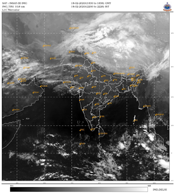
Satellite Image (Based on 17:30 hours IST):
 |
| Imd Satellite Image |
Region-wise Rainfall Statistics:
 |
| Imd State-Wise Rainfall Statistics |
Upcoming Weather Systems:
A fresh Western Disturbance is likely to affect Western Himalayan Region & adjoining plains from 20th February.


0 Comments
Please do not enter any spam link in the comment box.